What is this?
This is documentation of a century ride for the UMCA Year-Rounder Challenge. The basic idea is to make at least one 100-mile ride in each month of 2007. It gets me out when it might otherwise be too easy to say “too bad the weather wasn't better this month.”
August 5, 2007
Route Overview
Blackberrry bRamble Century, sponsored by Greater Eugene Area Riders (GEARS).
UMCA rules are unclear (some documents say that an organized ride is any with a web site, others say the web site can be submitted electronically only if it includes a list of finishers), so I'll document it both ways here. If it's counted as an organized ride, it is 100 miles even (on-course miles only). If it's counted as a personal century, then the mileage documented by GPS is a bit more.
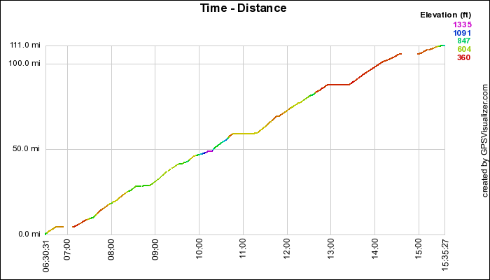
- Start ride: 6:30am, Southwest Eugene, OR
- Start course: 7:10am, EWEB plaza in Eugene, OR
- End of course: 2:30pm, EWEB plaza, Eugene, OR
- Stop ride: 3:35pm, Southwest Eugene, OR
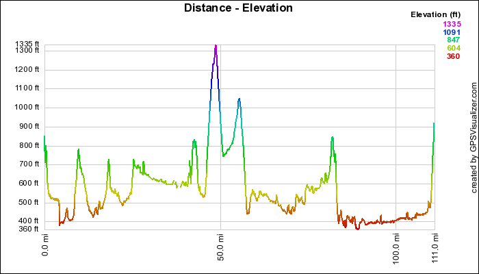
- Miles: 100 on course, 111 total
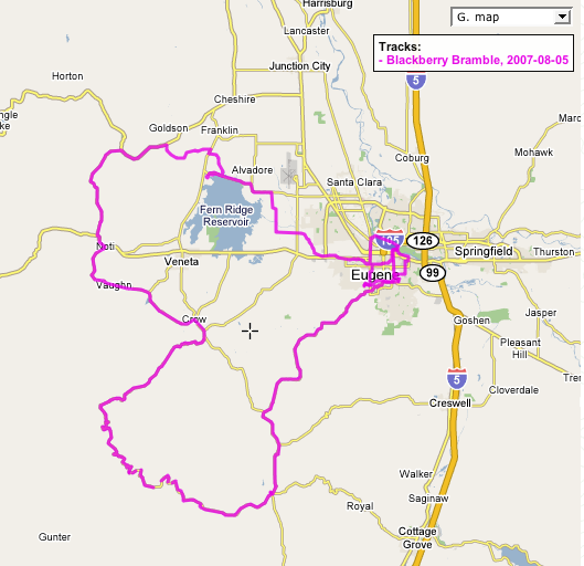
From EWEB plaza south to 29th and Lorane, then follow Lorane Hwy to its end at Gillespie Corners. Territorial Hwy south to town of Lorane (food stop). West on Siuslaw Hwy, follow to junction with Wolf Creek road. Over Wolf Creek road and down to Terrritorial Hwy. Lunch stop in Crow. Northwest Vaughan Road to Noti, short highway jog to Poodle Creek road, continue North on Poodle Creek to Hwy 36. West (right) on Hwy 36 to Lawrence, right on Lawrence to Butler, left on Butler. Butler is steep rollers followed by the fastest descent around, ending at Territorial Hwy. Short highway jog right (southwest) to Kirk Road, then left on Kirk for a few more rollers, ending at Clear Lake road. The bRamble detours right on Clear Lake to Richardson Park for the last food stop, then reverses and takes Clear Lake east to to Fir Butte, then north on Royal to Greenhill, just crossing Greenhill to take the Fern Ridge bicycle path back into town. At Chambers we leave the Fern Ridge bicycle path and cut north to the north River Bank trail, annd follow that trail east to Alton Baker Park, then across the Defazio bicycle bridge back to EWEB plaza.
Route map
The GPS track includes the ride to and from home, in addition to the bRamble course.
As gpx (open in some route viewing applications, including GPS Visualizer).
Time/Distance Plot
Distance/Elevation Profile